Theme 5
Getting around Boroondara
Strategic objective
Travel options that are connected, safe, accessible, environmentally sustainable and well-designed.
Key figures
- $6.1 million net operating cost
- 563 kilometres of local roads
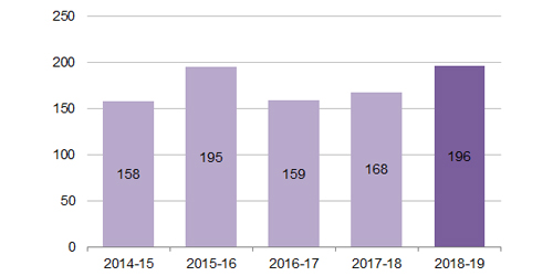
- 196 traffic counts and surveys.
Achievements
Sustainable travel options
Commitment
Provide paths and infrastructure on Council managed land and advocate for walking and cycling initiatives on arterial roads to increase active and environmentally sustainable travel options for the community.
Project overview
There was a distinctive unmade path in Patterson Reserve adjacent to Reserve Road, which was well utilised by pedestrians, including many Melbourne University students. In winter the unmade path would deteriorate further with the rain leading to access difficulties. Given the high usage of the unmade track, Council proposed to seal the existing trail to improve access and safety for pedestrians.
The local community had the opportunity to review the proposed path and provide feedback. Discussions were also had with Council officers to discuss the path alignment, clearance to trees and the materials to be used on the new path. The preferred path materials involved Lilydale toppings with a small section in exposed aggregate concrete.
Project aims
The project set out to improve accessibility and safety for all users, including pedestrians in Patterson Reserve between Robinson Road and Kooyongkoot Road.
Project outcomes
The new accessible path, extending for 250 metres was completed in September 2018 and is enjoyed by many in the wider community.
For more information, contact the Coordinator Transport Management on 9278 4518.
Summary of other achievements
- Council’s Community Transport service was reviewed and benchmarked with other like councils to design a service that is responsive to community need and ensures the most efficient service is delivered to the community. As a result of the review and benchmarking, a new bus route will be trialled to respond to local need.
- Continued advocacy on the North East Link (NEL), a proposed freeway-standard new road linking the Metropolitan Ring Road to the Eastern Freeway at Bulleen Road.
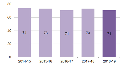
Community satisfaction with sealed local roads
Number of traffic counts and surveys
Challenges
- An increase in major developments (simultaneously in most cases) within the municipality has meant Council has had to focus more of its efforts into ensuring that developers manage their construction to minimise the impacts to the community.